Matching speed panels to segments
- This part took for 62 road sensors and 200 segments around 20 minutes to complete
- Code in Github
- You can read more about the execution logic in the speedpanel integration part of this document One of the key contributions of this dissertation was to integrate speedpanel data with GPS data. The speedpanel dataset consists of average speed observations in 2 minute time intervals. As the taxi dataset was available for year 2010, only speedpanels that were installed in year 2010 have been integrated as a data source to this project. The distribution of speedpanels in Hong Kong can be seen below
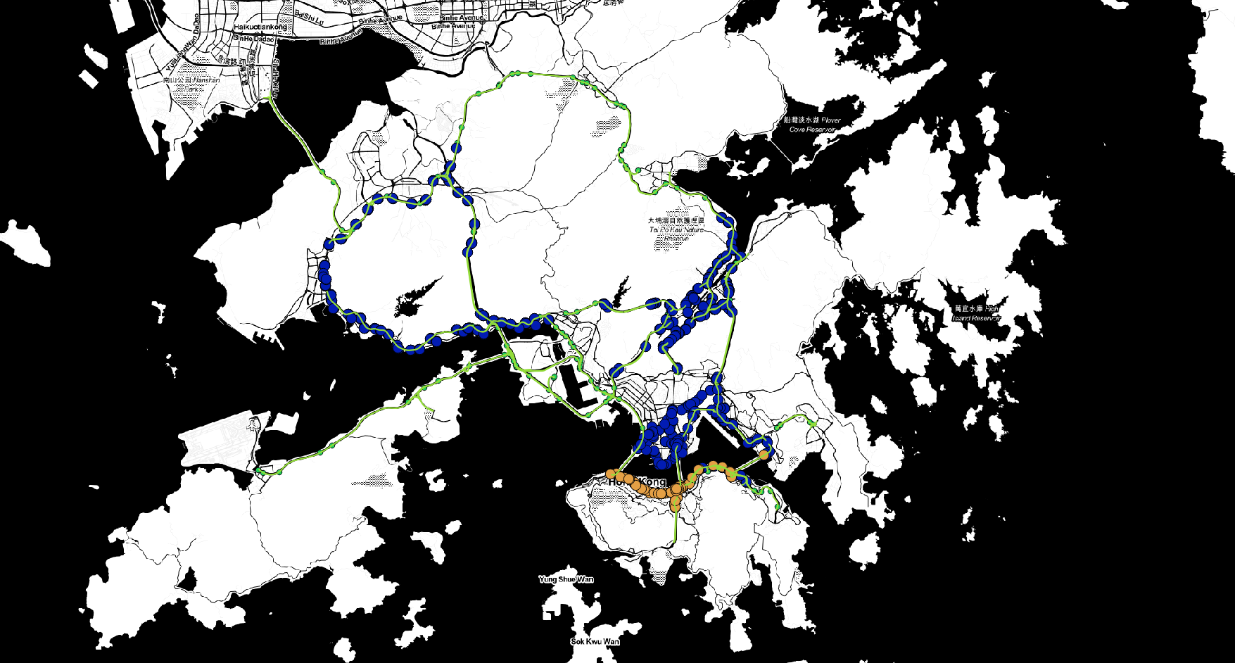
The road sensors analysed in this project are shown in beige. Newer road sensors installed after 2013 are shown in blue.
SPEED PANEL DATA TRANSFORMATION MODEL
Initial Table speedpanel.xls
This table contains spedpanel information transorfmed to xls based ont the file tsm_dataspec.pdf
| Link ID | Start Node | Start Node Eastings | Start Node Northings | End Node | End Node Eastings | End Node Northings | Region | Road Type |
|---|---|---|---|---|---|---|---|---|
| 722-50059 | 722 | 834038.674 | 816345.067 | 50059 | 833862.7 | 816441.553 | HK | MAJOR ROUTE |
| 724-722 | 724 | 834148.783 | 816250.647 | 722 | 834038.674 | 816345.067 | HK | URBAN ROAD |
| 752-875 | 752 | 835099.22 | 815634.373 | 875 | 834918.334 | 815759.379 | HK | URBAN ROAD |
| 756-752 | 756 | 835352.749 | 815640.774 | 752 | 835099.22 | 815634.373 | HK | URBAN ROAD |
| 760-756 | 760 | 835602.186 | 815600.695 | 756 | 835352.749 | 815640.774 |
StartNode.csv->20170925_163111_StartNode.csv, EndNode.csv->20170925_163111_EndNode.csv
Generated Based on the speedpanel.xls.
- I took the [1-3] (start form 0, inclusive) columns to generate StartNode.xls and then took the [4-6] columns to generate EndNode.xls
- I used the converter in the Hong Kong Mapping Office site to transform and add to table the corresponding coordinates in wgs84 format.
Settings:- HK80 Grid Coordinates(Northing, Easting) to WGS85 Geographic Coordinates (Latitude/Longitude)
- Format Decimal Degree(DDD.DDD) for input and output both.
| ID | Easting | Northing | Latitude(DDD.DDDDD) | Longitude(DDD.DDDDD) |
|---|---|---|---|---|
| 722 | 834038.674 | 816345.067 | 22.28599503 | 114.155241726 |
| 724 | 834148.783 | 816250.647 | 22.285142496 | 114.156310311 |
| 752 | 835099.22 | 815634.373 | 22.279578054 | 114.16553342 |
| 756 | 835352.749 | 815640.774 | 22.279636012 | 114.167993464 |
panels.xls
Just a regular speedpanel observation file with data where in columns there are around 70 speed panels listed and in rows there are observations for every 2 minutes in 24 hour sequence.
| Date | Time | Node 3402-8979 Speed (km/h) | Node 3402-8979 Color | Node 3402-8979 Travel Time (mins) | Node 3651-4632 Speed (km/h) | Node 3651-4632 Color |
|---|---|---|---|---|---|---|
| 1/1/2010 | 0:00:35 | 55.55472633 | G | 0.2 | 77.77887123 | G |
| 1/1/2010 | 0:02:35 | 55.55472633 | G | 0.2 | 69.5602234 | G |
| 1/1/2010 | 0:04:35 | 54.42624134 | G | 0.21 | 72.99038487 | G |
| 1/1/2010 | 0:06:35 | 55.55472633 | G | 0.2 | 77.77887123 | G |
| 1/1/2010 | 0:08:35 | 48.56595273 | G | 0.23 | 77.77887123 | G |
StartNodes.csv-result.csv, EndNodes.csv-result.csv
Here we store the filtered file based on the StartNode.xls, EndNode.xls. To do the filtering I retrieved (from panels.xls) speedpanel id-s we had in year 2010. I did the filtering because the files generated from speedpanel.xls contain all available speed panels in year 2017 which is a lot more.
| ID | Easting | Northing | Latitude(DDD.DDDDD) | Longitude(DDD.DDDDD) |
|---|---|---|---|---|
| 7882 | 836603.538 | 815878.324 | 22.282 | 114.18 |
| 7881 | 836592.753 | 815897.731 | 22.282 | 114.18 |
| 46488 | 835804.774 | 815605.457 | 22.279 | 114.172 |
| 4650 | 839919.319 | 816768.747 | 22.29 | 114.212 |
| 7883 | 836596.707 | 815890.625 | 22.282 | 114.18 |
| 4651 | 836884.007 | 816087.665 | 22.284 | 114.183 |
| 4652 | 833101.677 | 816778.101 | 22.29 | 114.146 |
Data formating
Base Map, against which incident detection is done data files
Andres Incident Detection Folder: /data/route_segmentation/
InitialRoutesMergedWhkCityArea.osm – Hong_Kong_Highways-Merged-Remove_Deleted.osm and HkCityArea.osm merged manually using JOSM programresultInitialRoutesMergedWhkCityArea.osm filtered out ways and nodes except for which belonged under ways categories : trunk, motorway_link, motorway;- Hong_Kong_Highways-Merged-Remove_deleted.osm
- HkCityArea.osm
- result_filtered-Hong_Kong_Highways-Merged-Remove_Deleted.osm
- result_filtered-HkCityArea.osm
- merged-filtered.osm - based on 2 previous merges(Merge done with JOSM*.jar in the downloads folder). If 2 nodes had same id, HkCityArea is preferred because this is newer.
- Hong-Kong-Result.osm – segmented routes created based on resultInitialRoutesMergedWhkCityArea.osm file
Specific descriptions
3 phases
- Formating the speedpanel nodes and speedpanel nodepairs into osm formating with wgs84 coordinates System
- Mapping speedpanels to mapmathing project base map. speedpanels.osm file with Hong-Kong-Result.osm file.
- Parsing speedpanel observations so they could be included under this project training and incident detection phase.
bgt.SpeedPanel.SpeedPanelToProjectFormater
- Manual Preprocessing - Based tsm_dataspec.pdf - Steps described above until generation of: 20170925_163111_StartNode.csv , 20170925_163111_EndNode.csv
- returns HashMap<String, Integer> panelNodeMap reads in speedpanel nodepairs and nodes from observation files in year 2010 (panels.xls example above)
- getCurrentSpeedPanelsOld() based on 1 file - reads in only speedpanels that existed in 1 day january 2010
- getCurrentSpeedPanels() based on all files - read in all speedpanels that existed or were installed in 2010
- filterSpeedPanelNodesCSV(String fileName) Filters speedpanels out from the files: 20170925_163111_StartNode.csv , 20170925_163111_EndNode.csv -> generates files: StartNodes.csv-result.csv, EndNodes.csv-result.csv
- speedPanels = k.readInSpeedPanelsCSV(String fileName) -> reads in speedpanel nodes from filtered files as rows.
- readSpeedPanelsToNodes(speedPanels);
- generateWaysFromNodeCombos();
- printWays(“old”); -
Input files
- tsm_dataspec.pdf
Intermediate files
-
panels.xls all files that contain speedpanel observations - StartNode.csv
- EndNode.csv
- 20170925_163111_StartNode.csv
- 20170925_163111_EndNode.csv
- 20170925_163111_StartNode.csv-result.csv - filtered files with speedpanel nodes
- 20170925_163111_EndNode.csv-result.csv - filtered files with speedpanel nodes
Output files
- oFileName +”speedPanelWays.osm” - file which contains speepanels pairs as ways with 2 nodes.
bgt.SpeedPanel.MatchSpeedPanelSegments extends MapMatcher
- MatchSpeedPanelSegments matchSpeedPanelSegments = new MatchSpeedPanelSegments(“speedPanelWays.osm”); - reads in speedPanels file as MapMatcher base map.
- matchSpeedPanelSegments.indexSegs(); - indexes the base map just like in gps observations matching
- matchSpeedPanelSegments.doMatching(); - matches Hong_Kong-result.osm segments to speed_panel based ways map.
- this.speedPanelSegs = matchToSpeedPanels(segRecs);
- printOutPanelsWSegments();
  Routes segmentResultRoutes = OSMparser.parseNodesAndWays("data/route_segmentation/Hong_Kong-result.osm");
  SegmentStructures ss = parseSegments(segmentResultRoutes);
  this.segmentsToMatch = ss.segMap;

  HashMap<String,List<Record>> segRecs = segToRecs(ss.segList);
  this.speedPanelSegs = matchToSpeedPanels(segRecs);
  System.out.println(this.speedPanelSegs);
  System.out.println(this.speedPanelSegs.size());
  printOutPanelsWSegments();
  printOutResult("data/speed_panels/spMatched.txt");
  return true;
Input
- data/speed_panels/intermediate_data/speedPanelWays.osm
- data/route_segmentation/Hong_Kong-result.osm
Output
- data/speed_panels/SpeedPanelSegments.osm
- data/speed_panels/spMatched.txt
bgt.SpeedPanel.AppendSpeedPanel ; bgt.SpeedPanel.SpeedPanelObsParser
After LInearInetporlation has finished. This class is responsible for adding speedPanel observations to the project.
- AppendSpeedPanel speedPanelParser = new AppendSpeedPanel(AppendSpeedPanel.PREFIX + “spMatched.txt”);
AppendSpeedPanel(String fileN) throws IOException { this.speedPanelSegs = SpeedPanelObsParser.readInSpSegs(fileN); } - speedPanelParser.appendAllObservations(GenerationType.TRAIN); - builds input for model training phase and appends this to linear interpolation result.
- speedPanelParser.appendAllObservations(GenerationType.TEST); - builds input for labeling phase, which the labeling phase must read in separately.
Input
- data/speed_panels/spMatched.txt
- all speedpanel observations files
Output
- data/speed_panels/append_train/train_interpolation_result” + foldNr + “.csv
251368918_0_0,73
251368918_0_0,76
251368918_0_0,73
251368918_0_0,73
251368918_0_0,77
251368918_0_0,74
251368918_0_0,76
251368918_0_0,75 - data/speed_panels/labeling/observations/+ foldNr + “.csv”
251368918_0_0,0:00:35,73,14/1/2010
251368918_0_0,0:02:35,76,14/1/2010
251368918_0_0,0:04:35,73,14/1/2010
251368918_0_0,0:06:35,73,14/1/2010
251368918_0_0,0:08:35,77,14/1/2010
251368918_0_0,0:10:35,74,14/1/2010
251368918_0_0,0:12:35,76,14/1/2010
251368918_0_0,0:14:35,75,14/1/2010
251368918_0_0,0:16:35,71,14/1/2010
251368918_0_0,0:18:35,75,14/1/2010
251368918_0_0,0:20:35,73,14/1/2010
251368918_0_0,0:22:35,70,14/1/2010
251368918_0_0,0:24:35,70,14/1/2010
Code pieces that contain speedpanel data formating code and short descriptions
After Route Segmentation Phase
bgt.parsing.OSMparser - added function: public static Routes parseFilterNodesAndWays(String fileName) which filters input files so the only ways that are accepted are: “trunk”,”motorway_link”,”motorway”: bgt.SpeedPanel.SpeedPanelToProjectFormater - formats speedpanels so their locations could be added to map. bgt.SpeedPanel.MatchSpeedPanelSegments extends MapMatcher - matches speedpanels to base map
After Linear Interpolation Phase
bgt.SpeedPanel.AppendSpeedPanel implements bgt.SpeedPanel.SpeedPanelBase - controller, which handles overall generatsion of data bgt.SpeedPanel.SpeedPanelObsParser bgt.SpeedPanel.SpeedPanelBase - parses observation files, copies append files. File to project handling. bgt.LabelData.LabelData - modified LoadRecsIntoSegs function here.
AMOUNT OF OBSERVATIONS
$702430*365$ ~ 19 000 000
Leave a Comment